A few days ago, we looked at a variety of sources to help orient our map of the Battle of Belington/Laurel Hill. Since then, I learned that most of these sources repeat, by second or third hand, information from the diary of a soldier in the 7th Indiana Regiment named William “Billy” Davis. His diary gives more details that allow us to pinpoint the exact location of landmarks mentioned in other sources.
When reading Billy’s diary, we have to keep in mind that his regiment faced south or southeast, so his “right” was west and “left” was east.
On July 8, 1861, he wrote:
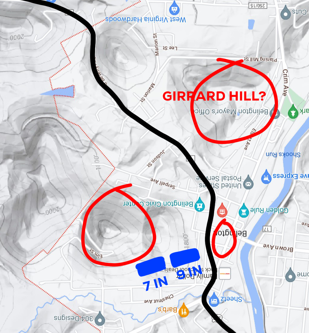
“now at nine o’clock the left wing of the 7th is at a fence facing to the South East, while the right wing is at a fence behind us facing to the North west. Are all waiting in line. Can hear Bugle calls in Rebel camp and an occasional shot at the front. Belington lies to our right beyond the 9th on the Pike. In front of Belington is a coneshaped hill on right of road, densely covered with timber. On left of road and more directly in our front is another round hill also timbered. Our picket line is at or near the border of this timber. It was on the hill to right where Captain Moody lost the two men yesterday. The one killed was Wm. T. Girrard… the soldiers have named the hill for the hero.”
If we look at a modern terrain map of Belington, turned upside down (looking at it from Billy’s perspective in the 7th Indiana), we can see where the 9th Indiana Regiment would be between the 7th and the town “on their right” along the Pike.
Directly in front of Belington is a large hill, that while not exactly “cone shaped”, is on the right side of the road and rises approximately 180 feet. This is the most likely candidate for Girrard Hill, named after a fallen comrade. He later describes Girrard Hill as “the hill to our right.”
He then says “On left of road and more directly in our front is another round hill”, which I have circled in red above. This hill rises approximately 260-280 feet above the town.
He also mentions the “old field” discussed in other sources, stating “More immediately in our front is an old field with here and there a clump of bushes, or briars, or a pile or logs. These were held by our skirmishers.” This suggests that it was a lot closer to Union lines than those other sources claim.
On July 12, he describes approaching the Confederate camp:
“…without stopping at the line we pushed on thru Belington. into the woods, around Girard Hill, to our right, and another hill to our left, emerging from the dense forest, at a turn of the road to the left, found the timber in front felled, forming a strong abatis, with the Rebel works in full view. having complete command of the road as it curved to the left around the mountain.”
This really helps bring the battlefield into focus, since he was writing his diary as the events unfolded, and with an eye for detail. Based on this information, we’ll have to revise our map a little, but each revision brings us closer to an accurate depiction of what happened and where.
