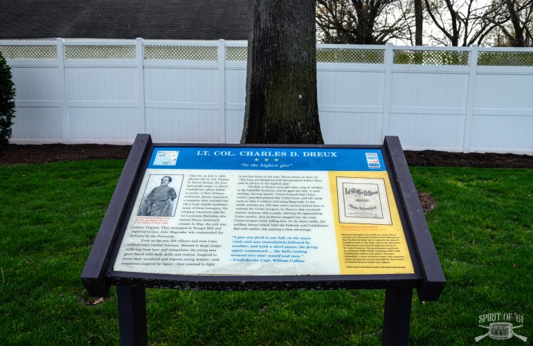
Map of June 1861 Actions around Romney, Virginia

I'm proud to announce our first official map--depicting the actions around Romney, Virginia (today, West Virginia) in June 1861, which pitted Lew Wallace's Indiana zouaves against a variety of Confederate forces sent to secure the area. Romney was a hotbed of secessionist support and Confederate forces there threatened the Baltimore & Ohio Railroad, which Lew…

Orienting the Laurel Hill Battle Map

The following descriptions, taken from a variety of sources, help identify major landmarks related to the Battle of Belington/Laurel Hill. Since there are few reliable maps of Camp Laurel Hill and none of unit positions, we have to rely on these written descriptions to tell us where the battle unfolded. The numbers correspond to areas…

Who Died at Righter’s House? An Early Civil War Mystery

An accurate accounting of Civil War casualties is often difficult, especially when record keeping was spotty at best. Newspaper articles, personal reminisces, and official reports are exaggerated and unreliable. This seems particularly true for the Action at Righter’s House, which was among the first deadly exchanges in the Civil War. On Friday, June 21, 1861,…

Orienting the Laurel Hill Spy Map

Yesterday, I shared a re-created map of Laurel Hill Camp drawn by a Union spy named William Fletcher. The Confederate Army of Northwestern Virginia occupied this position from June 16 to July 11, 1861. The camp didn't leave much in the way of physical remnants except for a small cemetery, so identifying its boundaries is…

Union Troops in Patterson’s Creek Skirmish

A few days ago, I posted an accounting of all Confederate soldiers involved in the Patterson's Creek / Kelley’s Island Skirmish. Having the names of all participants on the Confederate side only tells half the story, however, but I recently came across a contemporary newspaper article that sheds light on the Union troops involved. The…