Yesterday, I shared a re-created map of Laurel Hill Camp drawn by a Union spy named William Fletcher. The Confederate Army of Northwestern Virginia occupied this position from June 16 to July 11, 1861. The camp didn’t leave much in the way of physical remnants except for a small cemetery, so identifying its boundaries is a challenge for historians. Comparing the Fletcher map with modern terrain features, however, might help.
A few points of interest immediately stand out:
- The map is not oriented north-south. There is a rough compass on the original drawing pointing ‘up’ for north, but it is not correct. In this vacinity, the Beverly-Fairmont Turnpike runs east-west. So the map should be turned on its side.
- The creek, likely Mill Creek, enters from the left side (south), when it actually should enter from the right (north). Mill Creek flows from Laurel Mountain north through the battlefield until it ultimately turns west and enters the Tygart Valley River.
- A description of the camp in the Cincinnati Commercial stated: “on the left flank they have three long rifle pits”. There is some kind of entrenchment on the map located on what would be the Confederate left flank (near hill #5 below).

Comparing the Fletcher map with a topographical map from 1971, you can generally align the hills. Hill #1 and #4 extend from Laurel Mountain proper on either side of the road. Hill #2 and 3 are a bit more challenging. Hill #2 is east of the creek, so I’m thinking it’s a spur of Laurel Mountain. Hill #3 is some distance north of the Beverly-Fairmont Turnpike. There’s a hill rising to 1,983 feet in that vicinity, but I don’t think it has a name.
The Fletcher map shows the summit of Hill #5 in front of the rifle pits. The Confederate Cemetery is located on this hill. I think it would be strange for the Confederates to bury their dead in front of the firing line. Logically, they would bury their dead behind the front lines. The 1971 topographical map actually shows the cemetery in the wrong location (unless it’s been moved). The cemetery is on the backside of the hill near the “R” in “Mill Creek Reservoir.”
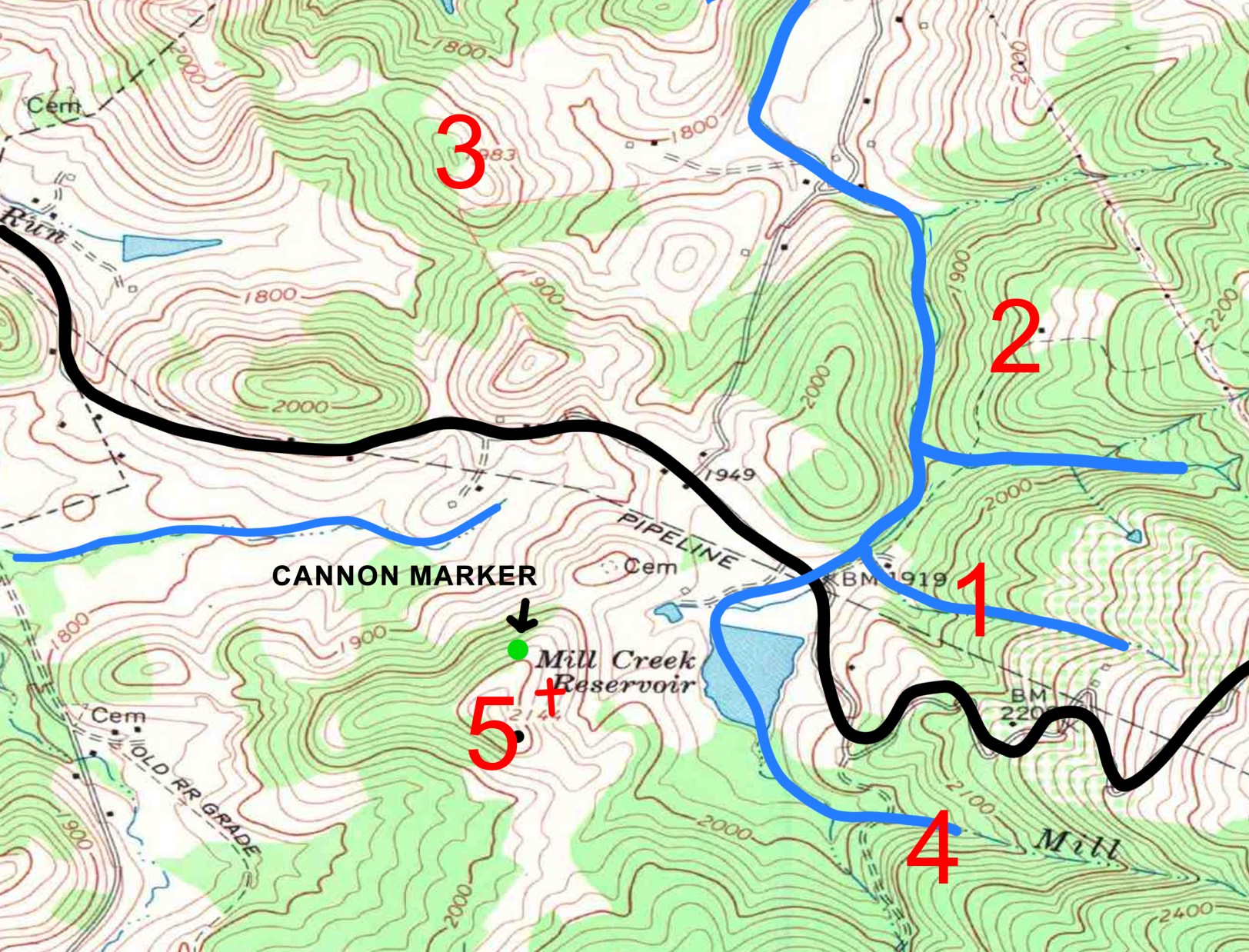
On the Laurel Hill Battlefield trail, there is an interpretive sign 115 yards northwest of the cemetery that claims “Confederate artillery was posted here. The cannons were placed behind protective earthworks, still faintly visible today.” Unfortunately, Union troops destroyed most of the Confederate earthworks after the battle, and time and erosion finished the job.
When trying to reconcile the Fletcher map with modern terrain, we should take into consideration that William Fletcher probably drew it from memory, or from a rough sketch. We have no idea the circumstances behind the map’s creation, whether Fletcher himself observed the camp’s layout, or he pieced together information from locals or Confederate prisoners. Still, I think it’s a good starting point.

One thought on “Orienting the Laurel Hill Spy Map”